

NIGHT SATELLITE IMAGE


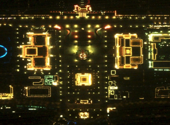
Satellite View of Earth at Night
The SP and GF03C satellites of JL1 constellection can conduct fast shooting with high-resolutions and multispectrums at night, which can reflect human activities
through luminous night time light data
Features of Night Light Satellite Images 1.High spatial resolution.
2.Multiple spectral bands and flexible data acquisition.
NIGHT SATELLITE IMAGE PARAMETERS
Indicators Parameter
SP03-08 GF03C
Substar point ground pixel resolution ≤ 0.92 m ≤ 1.2 m
Standard scene size (at nadir) 11 km×4.5km 14.4km×6km
Detection capability (a) Red:4.7
(b) Green:4.0
(c) Blue:4.2 (a) Red:4.2
(b) Green:3.6
(c) Blue:3.7
Positioning accuracy 30m
Available product level L1A; Luminous enhancement; Mosaic products
CGSTL (Changguang Satellite Technology Co., Ltd) is the first commercial remote sensing satellite companyin China. Now, CGSTL has set up the commercial business dealing with the development and operation of satellite as well as remote sensing information processing all in one.
If you need professional satellite data service, please leave us a message.
Отправить запрос, связаться с поставщиком
Другие товары поставщика
 |
SATELLITE IMAGE VIDEO | Satellite Image Video The SP, GF03C and MF satellites of JL1 constellection can gaze at a single target point for 120 seconds at most to record ... |
 |
SATELLITE CAMERAS | Satellite Cameras Specialized devices that take high-quality images from space. 5m-resolution Multispectral Camera 2m-resolution Micro-nano Came... |
 |
SATELLITE MISSION PLANNING | CONSTELLATION MISSION PLANNING SYSTEM SATELLITE MISSION PLANNING SOFTWARE FEATURES 1 The constellation mission planning system can accept the sh... |
 |
REMOTE SENSING IN FORESTRY | Remote sensing in forestryis a technology that uses the inherent characteristics of electromagnetic waves reflected or radiated by objects to ident... |
 |
Satellites Testing Services | The satellite communication testing services of CGSTL mainly consist of optical manufacture, satellite testing, and customized service. CHANGGUA... |
Похожие товары
 |
PHOTOGRAMMETRY REMOTE SENSING | Продавец: Chang Guang Satellite Technology Co., Ltd. | Photogrammetry remote sensingis to obtain reliable information about the earth, its environment a... |
 |
MARINE REMOTE SENSING | Продавец: Chang Guang Satellite Technology Co., Ltd. | MARINE REMOTE SENSING Ocean colour remote sensingrefers to remote sensing that takes the ocean a... |
 |
NIGHT SATELLITE IMAGE | Продавец: Chang Guang Satellite Technology Co., Ltd. | The SP and GF03C satellites of JL1 constellection can conduct fast shooting with high-resolutions... |
 |
MULTISPECTRAL IMAGES IN REMOTE SENSING | Продавец: Chang Guang Satellite Technology Co., Ltd. | Multispectral remote sensing refers to the multispectral data remote sensingtechnology that divid... |
 |
MULTI SPECTRAL IMAGERY | Продавец: Chang Guang Satellite Technology Co., Ltd. | The GP satellites of JL1 constellection have 26 spectral channels, covering optical remote sensin... |

