

Satellite Remote Sensing


Remote sensing is a non-contact, long-distance detection technology. Relying on the unique global data set of JL1, using our big data intelligence tool to understand the changes taking place in the areas you are most concerned about, and help you make decisions faster and better.
Types of Remote Sensing Satellites
Satellite Remote Sensing In Agriculture
Satellite Remote Sensing In Forestry
Satellite Remote Sensing In Environment
Satellite Remote Sensing In Change Monitoring
Satellite Remote Sensing In Greenbelt
Satellite Remote Sensing In Insurance
Multispectral Remote Sensing
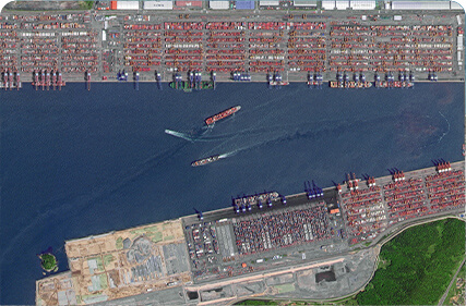
Ocean Remote Sensing
Optical Remote Sensing
Photogrammetry Remote Sensing
Thermal Remote Sensing
Customized Satellite Remote Sensing
REMOTE SENSING SATELLITE SYSTEMS-DETECTING THE EARTH
What is Remote Sensing
Remote sensing is a comprehensive earth observation technology developed in the 1960s. It generally refers to all non-contact long-distance detection, including detection of electromagnetic fields, force fields and mechanical waves (sound waves and seismic waves).
What is a Remote Sensing System
The remote sensing system mainly includes remote sensing information source, remote sensing information acquisition, remote sensing information processing and remote sensing information application.
Remote Sensing Information Application
With the development of the past few decades, satellite remote sensing technologyhas the characteristics of wide range of data acquisition, fast information acquisition speed, short information acquisition cycle, few information acquisition conditions, many means of information acquisition, and large amount of information. Remote sensing technology has been widely used in national defense, military, agriculture, forestry, land, ocean, surveying and mapping, meteorology, ecological environment, water conservancy, aerospace, geology, mining, archaeology and other fields.
Remote Sensing Data
Satellite remote sensing datais the starting point for remote sensing information services. Without timely, comprehensive and high-quality data supply, remote sensing applications cannot be operationalized. With the continuous development of the remote sensing application market and the continuous expansion of user groups, different users have their own needs for remote sensing information services, higher requirements.
Our Advantages
With the development of artificial intelligence technology, the processing of remote sensing big data has gradually become intelligent. Intelligent algorithms represented by deep learning have made breakthroughs in the field of computer vision. The thinking of "artificial intelligence" is subtly affecting the practice of remote sensing. There have been many applications in remote sensing image target detection and remote sensing coverage classification.
Outlook
As an important means of information acquisition, optical remote sensing satellitehas great potential to provide social services for many industries. It is an indisputable fact that artificial intelligence replaces some human work. "Artificial intelligence + remote sensing" has done a lot of excellent work in refined agricultural services, typical target recognition, and urban structure extraction.
03
EXPLORE REMOTE SENSING SATELLITE MARKETS
high resolution hyperspectral remote sensing satelliteslist
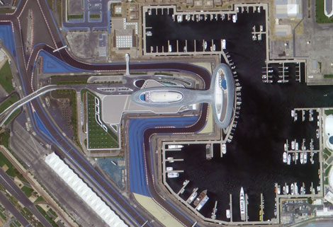
Urban Planning
The application of high-resolution remote sensing data to urban planning analysis is one of the main aspects of remote sensing applications, such as:
Dynamic monitoring of urban construction
Extraction of urban road network
Urban expansion monitoring
Urban environmental monitoring and assessment
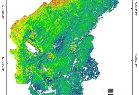
Environment
Remote sensing image has always been a powerful tool for environmental monitoring. Some of the feasible applications are:
Environmental impact assessment for a wide range of projects (natural resources exploitation, infrastructure development, etc)
River/Lake water bodies monitoring
Desertification processes monitoring and mitigation activities
Erosive processes analysis, restoration techniques planning and implementation
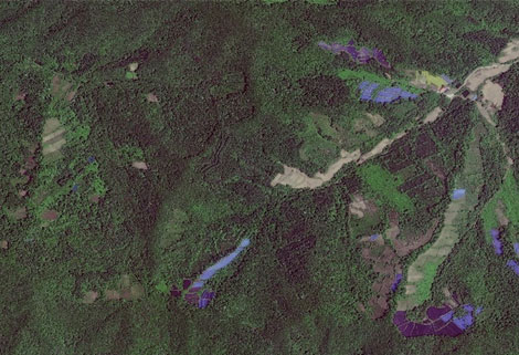
Agriculture
There is able to provide data for monitoring, mapping and deriving biophysical parameters and state of agricultural lands. Some of the possible applications are:
Crop spatial distribution
Crop condition monitoring
Agricultural reservation supervision
Agricultural disaster monitoring
As one of satellite manufacturers, we can offer kinds of satellite data productsfor sale, anything you need, please leave us a message.
Отправить запрос, связаться с поставщиком
Другие товары поставщика
 |
CUSTOMIZED SATELLITE TESTING SERVICE | Custom Satellite Solutions Jilin satellitecan provide customized remote-sensing information services to meet your specific needs. FEATURES OF CUS... |
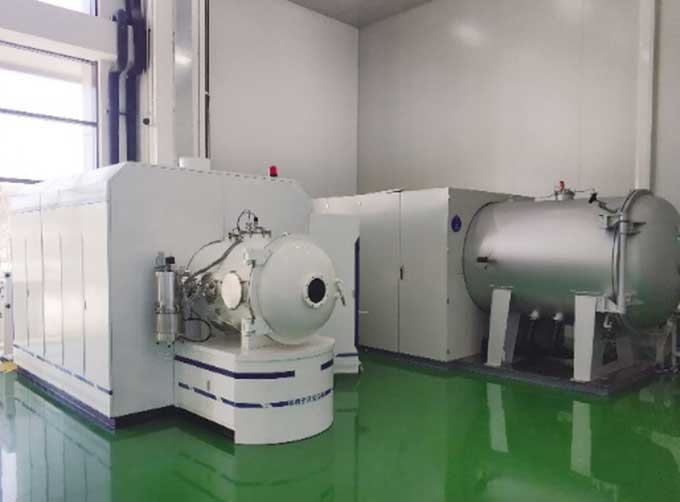 |
SATELLITE TESTING SERVICE | A key test satelliteprocedure in qualifying a satellite for launch. Component-level Thermal-vacuum Test Space Camera / Satellite Vacuum Heat E... |
 |
MARINE REMOTE SENSING | MARINE REMOTE SENSING Ocean colour remote sensingrefers to remote sensing that takes the ocean and coastal zone as the monitoring and research obj... |
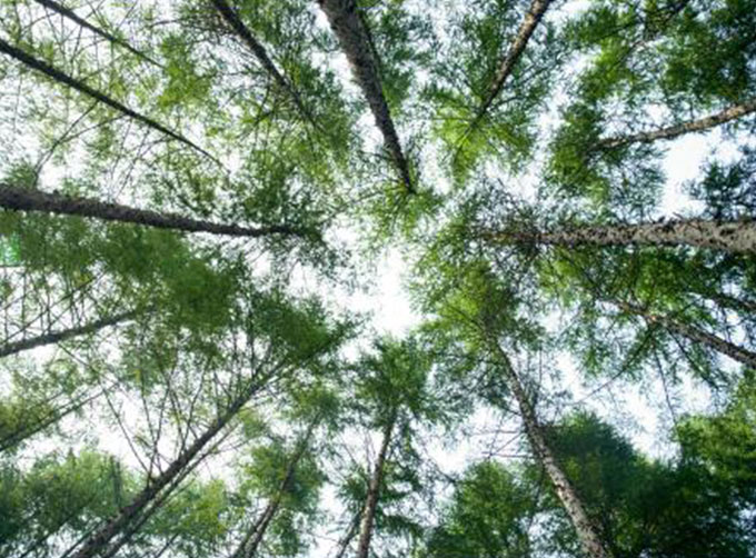 |
REMOTE SENSING IN FORESTRY | Remote sensing in forestryis a technology that uses the inherent characteristics of electromagnetic waves reflected or radiated by objects to ident... |
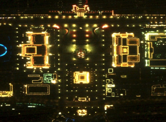 |
NIGHT SATELLITE IMAGE | Satellite View of Earth at Night The SP and GF03C satellites of JL1 constellection can conduct fast shooting with high-resolutions and multispectr... |
Похожие товары
 |
PHOTOGRAMMETRY REMOTE SENSING | Продавец: Chang Guang Satellite Technology Co., Ltd. | Photogrammetry remote sensingis to obtain reliable information about the earth, its environment a... |
|
|
MARINE REMOTE SENSING | Продавец: Chang Guang Satellite Technology Co., Ltd. | MARINE REMOTE SENSING Ocean colour remote sensingrefers to remote sensing that takes the ocean a... |
 |
NIGHT SATELLITE IMAGE | Продавец: Chang Guang Satellite Technology Co., Ltd. | The SP and GF03C satellites of JL1 constellection can conduct fast shooting with high-resolutions... |
 |
MULTISPECTRAL IMAGES IN REMOTE SENSING | Продавец: Chang Guang Satellite Technology Co., Ltd. | Multispectral remote sensing refers to the multispectral data remote sensingtechnology that divid... |
 |
MULTI SPECTRAL IMAGERY | Продавец: Chang Guang Satellite Technology Co., Ltd. | The GP satellites of JL1 constellection have 26 spectral channels, covering optical remote sensin... |
