

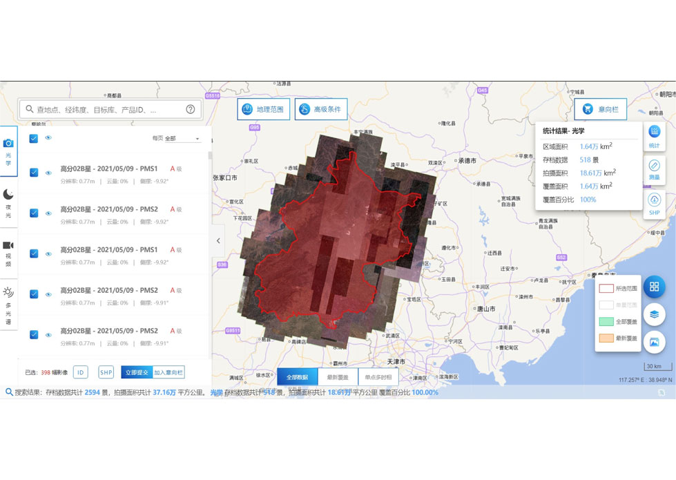
PUSH BROOM SCANNING SERVICE


The massive imagery archieved data and task programming data that cover all over the world captured by Jilin 1constellation. Great view and great details can be dicovered in our push broom scanningproduct.
The Resolution Is Better Than 0.5m Push Broom Scanning
The Resolution Is Better Than 0.75m Push Broom Scanning
The Resolution Is Better Than 1m Push Broom Scanning
FEATURES OF PUSH BROOM SCANNING SERVICE
1
Submeter high resolution (better than 0.5m)
2
High frequency revisit of point target
3
Fast coverage of large areas
4
Large shooting width (more than 150km)
If you want to know more kinds of along track scanner, please visit our website.
CGSTL (Changguang Jilin 1 SatelliteTechnology Co., Ltd) is the first commercial remote sensing satellite supplier in China. Now, CGSTL has set up a commercial business dealing with the development and operation of commercial satellites as well as remote sensing information processing all in one.
Отправить запрос, связаться с поставщиком
Другие товары поставщика
 |
SATELLITE DATA MANAGEMENT | DATA MANAGEMENT SYSTEM SATELLITE DATA MANAGEMENT FEATURES 1 The data management system is the center of the storage, management and applicatio... |
 |
Satellite Remote Sensing | Remote sensing is a non-contact, long-distance detection technology. Relying on the unique global data set of JL1, using our big data intelligence ... |
 |
INSURANCE SATELLITE REMOTE SENSING | Combining satellite remote sensing technologies with rights confirmation data and land parcel segmentation technology can vectorize and spatialize ... |
 |
PUSH BROOM SCANNING SERVICE | The massive imagery archieved data and task programming data that cover all over the world captured by JL1constellation. Great view and great detai... |
 |
MULTI SPECTRAL IMAGERY | Multispectral Image Data The GP satellites of JL1 constellection have 26 spectral channels, covering optical remote sensing data from visible ligh... |
Похожие товары
 |
PHOTOGRAMMETRY REMOTE SENSING | Продавец: Chang Guang Satellite Technology Co., Ltd. | Photogrammetry remote sensingis to obtain reliable information about the earth, its environment a... |
 |
MARINE REMOTE SENSING | Продавец: Chang Guang Satellite Technology Co., Ltd. | MARINE REMOTE SENSING Ocean colour remote sensingrefers to remote sensing that takes the ocean a... |
 |
NIGHT SATELLITE IMAGE | Продавец: Chang Guang Satellite Technology Co., Ltd. | The SP and GF03C satellites of JL1 constellection can conduct fast shooting with high-resolutions... |
 |
MULTISPECTRAL IMAGES IN REMOTE SENSING | Продавец: Chang Guang Satellite Technology Co., Ltd. | Multispectral remote sensing refers to the multispectral data remote sensingtechnology that divid... |
 |
MULTI SPECTRAL IMAGERY | Продавец: Chang Guang Satellite Technology Co., Ltd. | The GP satellites of JL1 constellection have 26 spectral channels, covering optical remote sensin... |
