

LUNAR SATELLITE IMAGES


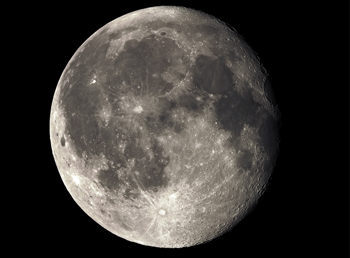
Jilin 1satellites can not only capture the images of the earth, but they can also turn the cameras to photograph space objects, such as the space station, the moon and other objects near the earth.
FeaturesofLunar Satellite Images
LUNAR SATELLITE IMAGES PARAMETERS
|
Indicators |
Parameter |
|
Angular resolution |
|
|
Standard duration |
10s; 30s; 60s |
|
Maximum duration |
120s |
|
Frame rate |
SP03-08:1/2/5/10 frame /s GF03C:1/2/5 frame /s (minimum 0.1, freely set) |
|
Standard field of view size |
SP03-08:1.1×0.5° for Single camera (SP04~08 is spliced by double cameras, and it is about 2.1×0.5°) GF03C series:1.5×0.6° |
|
Video image stabilization accuracy |
≤0.5 pixel |
|
Maximum angular velocity of maneuvering imaging |
≥ 1°/s |
|
Highest recognized magnitude |
SP03-08:12 magnitude GF03C series:10 magnitude |
|
Shooting satellite |
SP03-08; GF03C series |
If you want to know more types of commercial satellite, please contact us.
Отправить запрос, связаться с поставщиком
Другие товары поставщика
 |
Satellites Testing Services | The satellite communication testing services of CGSTL mainly consist of optical manufacture, satellite testing, and customized service. CHANGGUA... |
 |
SATELLITE PRODUCTS | Satellite Communication Products Jilin1satellite constellation is the core project of CGSTL. It is composed of 138 high-performance optical remo... |
 |
MULTI SPECTRAL IMAGERY | Multispectral Image Data The GP satellites of JL1 constellection have 26 spectral channels, covering optical remote sensing data from visible ligh... |
 |
PHOTOGRAMMETRY REMOTE SENSING | Photogrammetry remote sensingis to obtain reliable information about the earth, its environment and other natural objects and processes by using sa... |
 |
SATELLITE CAMERAS | Satellite Spy Camera Specialized devices that take high-quality images from space. 5m-resolution Multispectral Camera 2m-resolution Micro... |
Похожие товары
 |
PHOTOGRAMMETRY REMOTE SENSING | Продавец: Chang Guang Satellite Technology Co., Ltd. | Photogrammetry remote sensingis to obtain reliable information about the earth, its environment a... |
 |
MARINE REMOTE SENSING | Продавец: Chang Guang Satellite Technology Co., Ltd. | MARINE REMOTE SENSING Ocean colour remote sensingrefers to remote sensing that takes the ocean a... |
 |
NIGHT SATELLITE IMAGE | Продавец: Chang Guang Satellite Technology Co., Ltd. | The SP and GF03C satellites of JL1 constellection can conduct fast shooting with high-resolutions... |
 |
MULTISPECTRAL IMAGES IN REMOTE SENSING | Продавец: Chang Guang Satellite Technology Co., Ltd. | Multispectral remote sensing refers to the multispectral data remote sensingtechnology that divid... |
 |
MULTI SPECTRAL IMAGERY | Продавец: Chang Guang Satellite Technology Co., Ltd. | The GP satellites of JL1 constellection have 26 spectral channels, covering optical remote sensin... |
