

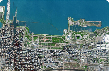
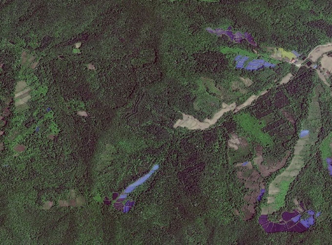
MULTI SPECTRAL IMAGERY


Multispectral Image Data
The GP satellites of JL1 constellection have 26 spectral channels, covering optical remote sensing data from visible light to long wave infrared.
FeaturesofMultispectral and Hyperspectral
MULTISPECTRAL DATA PARAMETERS
|
Indicators |
Parameter |
|
Substar point ground pixel resolution |
Visible light near infrared:5m; Shortwave/Mediumwave infrared camera:100m; Longwave infrared camera:150m |
|
Spectral bands |
B0:450nm-800nm B1:403nm-423nmB2:433nm-453nm B3:450nm-515nmB4:525nm-600nm B5:630nm-680nm B6:784.5nm-899.5nm B7:485nm-495nm B8:615nm-625nm B9:650nm-680nm B10:698.75nm-718.75nm B11:732.5nm-747.5nmB12:773nm-793nm B13:855nm-875nm B14:660nm-670nm B15:677.5nm-685nm B16:750nm-757.5nm B17:758.75nm-762.75nmB18:935nm-955nm B19:1000nm-1040nm SW1:1195nm-1225nm SW2:1360nm-1390nm SW3:1550nm-1590nm SW4:1610nm-1690nmMW:3700nm-4950nm LW:7500nm~13500nm |
|
Standard scene size (at nadir) |
Visible light near infrared:58.7km×58.7kmShortwave/Mediumwave infrared camera:64km×64kmLongwave infrared camera: 96km×96km |
|
Positioning accuracy |
50m (CE90) |
|
Photographic mode |
Push-broom |
|
Photographic satellite |
GP01; GP02 |
As a satellite factory, we can offer kinds of satellite data productsfor sale, if you have needs, please contact us.
Отправить запрос, связаться с поставщиком
Другие товары поставщика
 |
SATELLITE COMPONENTS PRODUCT | Cubesat Componentsand Satellite ComponentsProduct It is used for mechanical connection between each single machine and satellite. Satellite - R... |
|
|
MULTI SPECTRAL IMAGERY | Multispectral Image Data The GP satellites of JL1 constellection have 26 spectral channels, covering optical remote sensing data from visible ligh... |
 |
GREENBELT SATELLITE REMOTE SENSING | Greenbelt grass remote sensingis a technology that is used to detect and analyze the type distribution and biomass of grassland resources. Jilin... |
 |
SATELLITE PRODUCTS | SATELLITE PRODUCTS Jilin 1 satelliteconstellation is the core project of CGSTL. It is composed of 138 high-performance optical remote sensing sate... |
 |
CUSTOMIZED SATELLITE TESTING SERVICE | Custom Satellite Solutions Jilin satellitecan provide customized remote-sensing information services to meet your specific needs. FEATURES OF C... |
Похожие товары
 |
PHOTOGRAMMETRY REMOTE SENSING | Продавец: Chang Guang Satellite Technology Co., Ltd. | Photogrammetry remote sensingis to obtain reliable information about the earth, its environment a... |
 |
MARINE REMOTE SENSING | Продавец: Chang Guang Satellite Technology Co., Ltd. | MARINE REMOTE SENSING Ocean colour remote sensingrefers to remote sensing that takes the ocean a... |
 |
NIGHT SATELLITE IMAGE | Продавец: Chang Guang Satellite Technology Co., Ltd. | The SP and GF03C satellites of JL1 constellection can conduct fast shooting with high-resolutions... |
 |
MULTISPECTRAL IMAGES IN REMOTE SENSING | Продавец: Chang Guang Satellite Technology Co., Ltd. | Multispectral remote sensing refers to the multispectral data remote sensingtechnology that divid... |
 |
MULTI SPECTRAL IMAGERY | Продавец: Chang Guang Satellite Technology Co., Ltd. | The GP satellites of JL1 constellection have 26 spectral channels, covering optical remote sensin... |

