

SATELLITE MISSION PLANNING


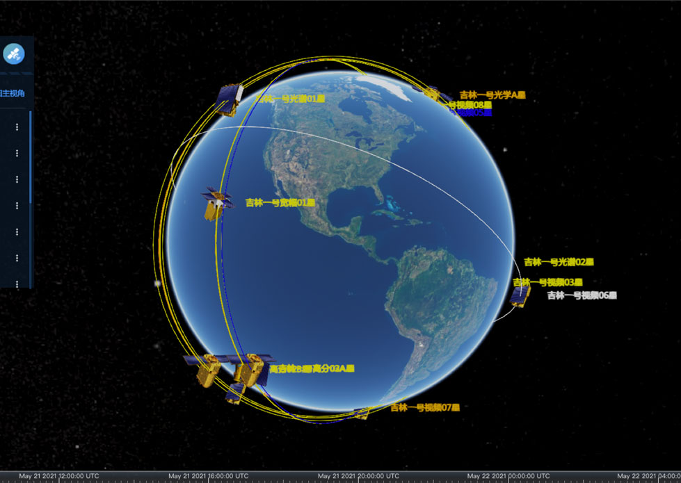
CONSTELLATION MISSION PLANNING SYSTEM
SATELLITE MISSION PLANNING SOFTWARE FEATURES
1
The constellation mission planning system can accept the shooting needs of users, track the completion of shooting needs.
2
Simulate the scheduling of on-orbit satellites' resources, and conduct visibility analysis of target areas or target points required by users.
WHAT ARE THE BENEFITS OF USING SATELLITE MISSION PLANNING SOFTWARE?
1
Optimizing mission performance: Satellite mission planning softwareenables engineers and mission planners to model and simulate different aspects of a mission, such as the satellite's orbit, communication, and data collection. This allows them to optimize mission performance and ensure that the satellite meets its objectives.
2
Reducing costs: By using satellite mission planningsoftware, organizations can reduce the costs associated with commercial satellitedevelopment, launch, and operation. They can identify potential issues and risks in advance, allowing them to take proactive measures to mitigate them.
3
Improving efficiency: Satellite design softwareallows organizations to automate and streamline many of the processes involved in satellite mission planning and operation. This improves efficiency and reduces the risk of errors.
4
Identifying potential issues: Satellite mission planning software allows organizations to model different scenarios and identify potential issues and risks in advance. This allows them to take proactive measures to mitigate them and ensure earth station satellite mission success.
5
Facilitating collaboration: Satellite mission planning software enables engineers and mission planners to collaborate more effectively and share information more easily. This improves communication and helps ensure that everyone involved in the mission is on the same page.
If you want to download space mission design and analysis pdfand satellite communications network design and analysis pdf, please visit our website.
As one of commercial satellite manufacturers, we can offer kinds of related products for sale, anything you need, please contact us.
Отправить запрос, связаться с поставщиком
Другие товары поставщика
 |
Satellites Testing Services | The satellite communication testingservices of CGSTL mainly consist of optical manufacture, small satellite testing, and customized service. SAT... |
 |
NIGHT SATELLITE IMAGE | The SP and GF03C satellites of JL1 constellection can conduct fast shooting with high-resolutions and multispectrums at night, which can reflect hu... |
 |
Satellite Hardware | The satellite communication hardwares of CGSTL mainly consist of satellite products, CubeSat platform, satellite cameras, standalone products, and ... |
 |
SATELLITE REMOTE SENSING IN AGRICULTURE | SATELLITE REMOTE SENSING IN AGRICULTURE Agricultural remote sensing refers to the comprehensive technology of agricultural applications such as us... |
 |
INSURANCE SATELLITE REMOTE SENSING | Combining satellite and remote sensingtechnologies with rights confirmation data and land parcel segmentation technology can vectorize and spatiali... |
Похожие товары
 |
PHOTOGRAMMETRY REMOTE SENSING | Продавец: Chang Guang Satellite Technology Co., Ltd. | Photogrammetry remote sensingis to obtain reliable information about the earth, its environment a... |
 |
MARINE REMOTE SENSING | Продавец: Chang Guang Satellite Technology Co., Ltd. | MARINE REMOTE SENSING Ocean colour remote sensingrefers to remote sensing that takes the ocean a... |
|
|
NIGHT SATELLITE IMAGE | Продавец: Chang Guang Satellite Technology Co., Ltd. | The SP and GF03C satellites of JL1 constellection can conduct fast shooting with high-resolutions... |
 |
MULTISPECTRAL IMAGES IN REMOTE SENSING | Продавец: Chang Guang Satellite Technology Co., Ltd. | Multispectral remote sensing refers to the multispectral data remote sensingtechnology that divid... |
 |
MULTI SPECTRAL IMAGERY | Продавец: Chang Guang Satellite Technology Co., Ltd. | The GP satellites of JL1 constellection have 26 spectral channels, covering optical remote sensin... |
