

STEREO SATELLITE DATA


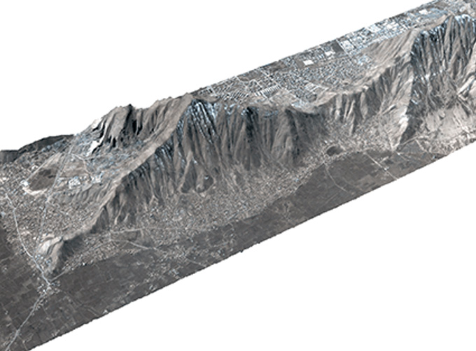
The data of SP or GF satellites of JL1 constellection can be used as stereoscopic mapping to produce DSM results with resolution better than 1m.
FEATURES OF STEREO DATA
1
High timeliness and strong shooting ability
Stereo Video DatasetParameters
|
Indicators |
Parameter |
|
Product type |
Stereo image pair; DSM; DEM |
|
Grid accuracy |
≤ 3m |
|
Elevation median error |
≤ 3m |
|
Photographic mode |
Coorbital stereo |
|
Photographic satellite |
GF02 series; SP03-08; GF03C series |
If you want to know more details of 3d point cloud from stereo images opencv, please visit our website.
Changguang Jilin satelliteconstellation is the core project under construction by CGSTL. The first phase of the project consists of 138 high-performance optical remote sensing satellites covering video, high resolution, wide band, infrared, multispectral and other series.
As a satellite services company, we will do our best to meet all the needs of customers.
Отправить запрос, связаться с поставщиком
Другие товары поставщика
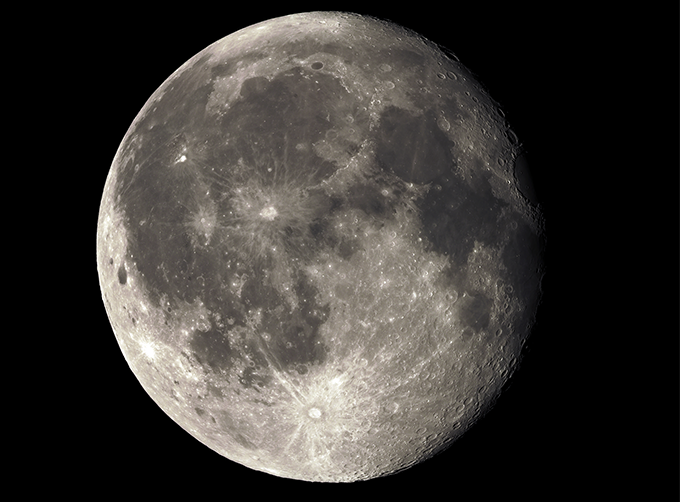 |
LUNAR SATELLITE IMAGES | Jilin 1satellites can not only capture the images of the earth, but they can also turn the cameras to photograph space objects, such as the space s... |
 |
REMOTE SENSING IN ENVIRONMENT | remote sensing in environmentis a general term for monitoring, evaluating and forecasting the dynamic changes of the natural and social environment... |
 |
CUSTOMIZED SATELLITE TESTING SERVICE | Custom Satellite Solutions Jilin satellitecan provide customized remote-sensing information services to meet your specific needs. FEATURES OF CUS... |
 |
MULTISPECTRAL IMAGES IN REMOTE SENSING | Multispectral remote sensing refers to the multispectral data remote sensingtechnology that divides the electromagnetic wave radiated by ground obj... |
 |
INSURANCE SATELLITE REMOTE SENSING | Combining satellite and remote sensingtechnologies with rights confirmation data and land parcel segmentation technology can vectorize and spatiali... |
Похожие товары
 |
PHOTOGRAMMETRY REMOTE SENSING | Продавец: Chang Guang Satellite Technology Co., Ltd. | Photogrammetry remote sensingis to obtain reliable information about the earth, its environment a... |
 |
MARINE REMOTE SENSING | Продавец: Chang Guang Satellite Technology Co., Ltd. | MARINE REMOTE SENSING Ocean colour remote sensingrefers to remote sensing that takes the ocean a... |
 |
NIGHT SATELLITE IMAGE | Продавец: Chang Guang Satellite Technology Co., Ltd. | The SP and GF03C satellites of JL1 constellection can conduct fast shooting with high-resolutions... |
|
|
MULTISPECTRAL IMAGES IN REMOTE SENSING | Продавец: Chang Guang Satellite Technology Co., Ltd. | Multispectral remote sensing refers to the multispectral data remote sensingtechnology that divid... |
 |
MULTI SPECTRAL IMAGERY | Продавец: Chang Guang Satellite Technology Co., Ltd. | The GP satellites of JL1 constellection have 26 spectral channels, covering optical remote sensin... |
