

REMOTE SENSING IN ENVIRONMENT


Satellite Environmental Monitoring
Remote sensing in environmentis a general term for monitoring, evaluating and forecasting the dynamic changes of the natural and social environment by using various remote sensing technologies. Environmental remote sensing can quickly provide reliable basis for environmental monitoring, evaluation and prediction.
MAIN PRODUCT SYSTEM CONTENTS OF ENVIRONMENTAL PROTECTION REMOTE SENSING SERVICE OF CGSTL
|
Product name |
Service frequency |
|
|
1 |
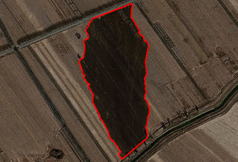
Bare soil dust source monitoring product |
Basic: Once a month |
|
Customized: On demand |
||
|
2 |
Straw incineration and full quantitative disposal monitoring product |
Straw burning:10 times/minute |
|
Straw removal/burning:2-3 times/month |
||
|
3 |
Urban and rural black-smelly water pollution monitoring product |
Basic: Once a quarter |
|
Customized: On demand |
||
|
4 |
Irregular solid waste stacking monitoring product |
Basic: Once a month |
|
Customized: On demand |
||
|
5 |
Ecological protection warning line monitoring product |
Basic: Once a quarter |
|
Customized: On demand |
If you want to get co2 emissions monitoringdata, please visit our website.
ChangguangSatellite Technology Co., Ltd. ( CGSTL), founded on December 1st, 2014, it's a unique commercial aerospace enterprise with the development and operation of commercial satelliteresearch, management as well as remote sensing information processing all in one. With a total registered capital of 1.97 billion RMB, the company comprises Jilin Provincial Government, Changchun Institute of Optics, Fine Mechanics and Physics (CIOMP), social capital, and technical backbone.
Send product request
Other supplier products
 |
SATELLITE IMAGE VIDEO | Satellite Image Video The SP, GF03C and MF satellites of JL1 constellection can gaze at a single target point for 120 seconds at most to record ... |
 |
CUSTOMIZED SATELLITE TESTING SERVICE | Custom Satellite Solutions Jilin satellitecan provide customized remote-sensing information services to meet your specific needs. FEATURES OF CUS... |
 |
MARINE REMOTE SENSING | Oceanographic Applications of Remote Sensing Ocean color remote sensing refers to remote sensing that takes the ocean and coastal zone as the moni... |
 |
INSURANCE SATELLITE REMOTE SENSING | Combining satellite remote sensing technologies with rights confirmation data and land parcel segmentation technology can vectorize and spatialize ... |
 |
SATELLITE TESTING SERVICE | A key test satelliteprocedure in qualifying a satellite for launch. Component-level Thermal-vacuum Test Space Camera / Satellite Vacuum Heat E... |
Same products
 |
PHOTOGRAMMETRY REMOTE SENSING | Seller: Chang Guang Satellite Technology Co., Ltd. | Photogrammetry remote sensingis to obtain reliable information about the earth, its environment a... |
 |
MARINE REMOTE SENSING | Seller: Chang Guang Satellite Technology Co., Ltd. | MARINE REMOTE SENSING Ocean colour remote sensingrefers to remote sensing that takes the ocean a... |
 |
NIGHT SATELLITE IMAGE | Seller: Chang Guang Satellite Technology Co., Ltd. | The SP and GF03C satellites of JL1 constellection can conduct fast shooting with high-resolutions... |
 |
MULTISPECTRAL IMAGES IN REMOTE SENSING | Seller: Chang Guang Satellite Technology Co., Ltd. | Multispectral remote sensing refers to the multispectral data remote sensingtechnology that divid... |
 |
MULTI SPECTRAL IMAGERY | Seller: Chang Guang Satellite Technology Co., Ltd. | The GP satellites of JL1 constellection have 26 spectral channels, covering optical remote sensin... |

