COTP VEHICLE-MOUNTED SATELLITE TERMINAL
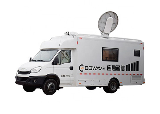
Cowave's COTPsatelliteterminal can set the rapid command with the configuration of a 1.2meter aperture satellite antenna, high-speed satellite modem, and integrated video conference system. For emergency situations, this SATCOM vehicle can arrive and set the satellite antenna to operation quickly, it can align to the satellite automatically and set a stable and reliable satellite link to the network. With a compact room and video system for a conference on board, the on-scene command can ensure support for the emergency rescue in some disaster-hit areas suffering from climate or geological hazards.
Specification of COTP Vehicle-mounted Satellite Terminal
|
COLLECTING TIME |
≤ 3 mins |
|
INTERMODULATION DISTORTION IM3 |
≥ -40dBc |
|
ANTENNA APERTURE |
|
|
ANTENNA TYPE |
Parabolic antenna |
|
POLARIZATION MODE |
Linear polarization |
|
THRESHOLD EB/N0 |
|
|
IP SERVICE MODEL |
Bridge or Routing |
|
AZIMUTH ROTATION |
±220° |
|
PITCH ROTATION |
0°~90° |
|
POLARIZATION ROTATION |
±270° |
|
SATELLITE AIMING TIME |
≤ 5 mins |
|
WORKING FREQUENCY |
Sending: 14.0GHz~14.5GHz, Receiving: 12.25GHz~12.75GHz |
|
BUC POWER |
16W |
|
SUPPORT SERVICES |
Voice, Video, Picture, Text, Short Voice Message, Data |
|
DATA RATE |
32Kbps~10Mbps |
|
MODULATION |
QPSK, 8PSK |
|
CODING |
LDPC(1/2, 3/4) |
|
DATA INTERFACE |
RJ45, Wi-Fi |
|
SECURITY (OPTIONAL) |
AES data encryption, RSA Key exchange |
|
OPERATING TEMPERATURE |
-40℃ ~ +55℃ |
Features of COTP Vehicle-mounted Satellite Terminal
01
Designed for on-scene commanding works and communication, easy to operate.
02
Provide high-speed bandwidth to support the transmission of multi-channel HD video.
03
Align to satellite and access to the network automatically, turn on and operate quickly.
04
With Independent Property Intelligent Rights and high customizability.
COTP Vehicle-mounted Terminal Satellite CommunicationGallery
Equipped with a 1.2m aperture satellite antenna, a high-speed satellite modem, and a compact video conference system to support the on-site commanding works.
If you want to know more applications of in motion hd satellite system, please visit our website.
As a satellite communication equipment provider, we will do our best to meet all the needs of customers.
在线联系供应商
Other supplier products
| COTP VEHICLE-MOUNTED SATELLITE TERMINAL | Cowave's COTPsatelliteterminal can set the rapid command with the configuration of a 1.2meter aperture satellite antenna, high-speed satellite mode... | |
| SHIPBORNE SATCOM TERMINAL | Cowave Shipborne SATCOM terminal can be installed on various kinds of ships or vessels to provide SATCOM ship services between ships and land or be... | |
| PORTABLE SATCOM TERMINAL | Cowave Portable SATCOM VSAT Terminal is designed for emergency communication. The compact design brings its characteristics of small size, lightwei... | |
| SATELLITE MODEM | The vsat modemcan be used to modulate and demodulate SATCOM signals. Its modulation and coding methods can meet international common standards a... | |
| SATELLITE ROUTER | satellite wireless router satellite internet modem router ht2000 satellite router ax1800 satellite satellite broadband router satellite wifi b... |
Same products
| PHOTOGRAMMETRY REMOTE SENSING | 卖方: Chang Guang Satellite Technology Co., Ltd. | Photogrammetry remote sensingis to obtain reliable information about the earth, its environment a... | |
| MARINE REMOTE SENSING | 卖方: Chang Guang Satellite Technology Co., Ltd. | MARINE REMOTE SENSING Ocean colour remote sensingrefers to remote sensing that takes the ocean a... | |
| NIGHT SATELLITE IMAGE | 卖方: Chang Guang Satellite Technology Co., Ltd. | The SP and GF03C satellites of JL1 constellection can conduct fast shooting with high-resolutions... | |
| MULTISPECTRAL IMAGES IN REMOTE SENSING | 卖方: Chang Guang Satellite Technology Co., Ltd. | Multispectral remote sensing refers to the multispectral data remote sensingtechnology that divid... | |
| MULTI SPECTRAL IMAGERY | 卖方: Chang Guang Satellite Technology Co., Ltd. | The GP satellites of JL1 constellection have 26 spectral channels, covering optical remote sensin... |


