

SATELLITE IMAGE VIDEO


Satellite Image Video
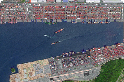
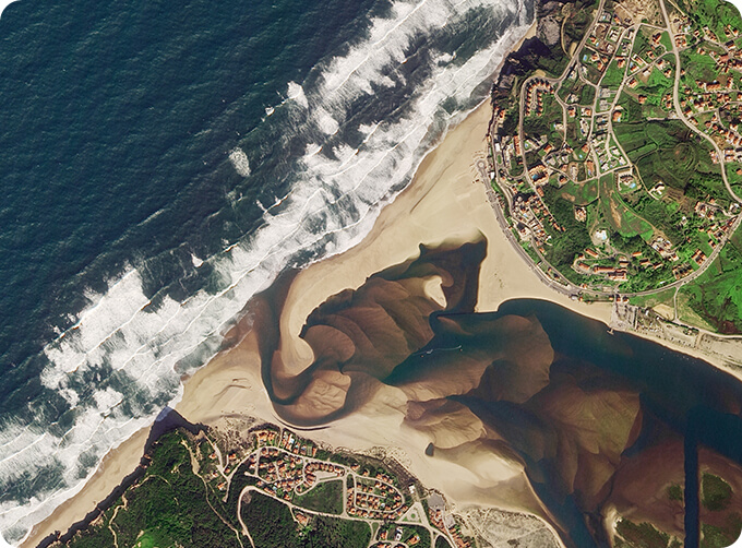
The SP, GF03C and MF satellites of JL1 constellection can gaze at a single target point for 120 seconds at most to record the instantaneous changes of ground objects.
FeaturesofLive Satellite Video of Earth
1
Track the target.
2
Record the track and analyze the situation.
SATELLITE IMAGE VIDEO PARAMETERS
Indicators
Parameter
SP03
SP04-08
GF03C
Substar point ground pixel resolution
Panchromatic:≤ 0.92 m
Panchromatic:≤ 1.2 m
Spectral bands
BLUE:410-500nm
GREEN:500-580nm
RED:580-690nm
BULE:437-512nm
GREEN:489-585nm
RED:580-723nm
BLUE:437-512nm
GREEN:489-585nm
RED:580-723nm
Standard scene size (at nadir)
11 km×4.5km
Standard duration
10s; 30s; 60s
Frame rate
5 frame /s
Radiation accuracy
3%
Video image stabilization accuracy
≤ 0.5 pixel
OTHER JL1 SATELLITES DATA
Night Time Data
Stereo Data
Changguang Jilin 1satellite constellation is the core project under construction by CGSTL. The first phase of the project consists of 138 high-performance optical remote sensing satellitescovering video, high resolution, wide band, infrared, multispectral and other series.
在线联系供应商
Other supplier products
 |
MULTI SPECTRAL IMAGERY | The GP satellites of JL1 constellection have 26 spectral channels, covering optical remote sensing data from visible light to long wave infrared. ... |
 |
Satellite Hardware | The satellite communication hardwares of CGSTL mainly consist of satellite products, CubeSat platform, satellite cameras, standalone products, and ... |
 |
JL1 Satellite Services | The technical index and function mode in terms of satellites research are taking the leading position in the world. Various satellite services such... |
 |
SATELLITE GROUND SYSTEMS | The mission of the ground satellitesystem is to track, measure and control the earth resources satellite, implement functional management, and rece... |
 |
PUSH BROOM SCANNING SERVICE | The massive imagery archieved data and task programming data that cover all over the world captured by Jilin 1constellation. Great view and great d... |
Same products
 |
PHOTOGRAMMETRY REMOTE SENSING | 卖方: Chang Guang Satellite Technology Co., Ltd. | Photogrammetry remote sensingis to obtain reliable information about the earth, its environment a... |
 |
MARINE REMOTE SENSING | 卖方: Chang Guang Satellite Technology Co., Ltd. | MARINE REMOTE SENSING Ocean colour remote sensingrefers to remote sensing that takes the ocean a... |
 |
NIGHT SATELLITE IMAGE | 卖方: Chang Guang Satellite Technology Co., Ltd. | The SP and GF03C satellites of JL1 constellection can conduct fast shooting with high-resolutions... |
 |
MULTISPECTRAL IMAGES IN REMOTE SENSING | 卖方: Chang Guang Satellite Technology Co., Ltd. | Multispectral remote sensing refers to the multispectral data remote sensingtechnology that divid... |
|
|
MULTI SPECTRAL IMAGERY | 卖方: Chang Guang Satellite Technology Co., Ltd. | The GP satellites of JL1 constellection have 26 spectral channels, covering optical remote sensin... |

