

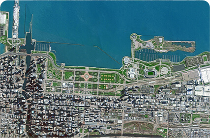
PUSH BROOM SCANNING SERVICE


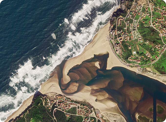
The massive imagery archieved data and task programming data that cover all over the world captured by JL1constellation. Great view and great details can be dicovered in our push broom scanningproduct.
The Resolution Is Better Than 0.5m Push Broom Scanning
The Resolution Is Better Than 0.75m Push Broom Scanning
The Resolution Is Better Than 1m Push Broom Scanning
FEATURES OF PUSH BROOM SCANNING SERVICE
1
Submeter high resolution (better than 0.5m)
2
High frequency revisit of point target
3
Fast coverage of large areas
4
Large shooting width (more than 150km)
OTHER JL1 SATELLITES DATA
Night Time Data
Satellite Image Video
LATEST NEWS ABOUT JL1
Satellite Remote SensingMonitoring for Refined Agricultural Production
If you want to know more kinds of along track scanner, please visit our website.
Send product request
Other supplier products
 |
SATELLITE COMPONENTS PRODUCT | Cubesat Componentsand Satellite ComponentsProduct It is used for mechanical connection between each single machine and satellite. Satellite - R... |
 |
PUSH BROOM SCANNING SERVICE | The massive imagery archieved data and task programming data that cover all over the world captured by Jilin 1constellation. Great view and great d... |
 |
PHOTOGRAMMETRY REMOTE SENSING | Photogrammetry remote sensingis to obtain reliable information about the earth, its environment and other natural objects and processes by using sa... |
 |
SATELLITE GROUND SYSTEMS | The mission of the ground satellitesystem is to track, measure and control the earth resources satellite, implement functional management, and rece... |
 |
REMOTE SENSING IN FORESTRY | Applications of remote sensing in forestry Remote sensing in forestryis a technology that uses the inherent characteristics of electromagnetic wav... |
Same products
|
|
PHOTOGRAMMETRY REMOTE SENSING | Seller: Chang Guang Satellite Technology Co., Ltd. | Photogrammetry remote sensingis to obtain reliable information about the earth, its environment a... |
 |
MARINE REMOTE SENSING | Seller: Chang Guang Satellite Technology Co., Ltd. | MARINE REMOTE SENSING Ocean colour remote sensingrefers to remote sensing that takes the ocean a... |
 |
NIGHT SATELLITE IMAGE | Seller: Chang Guang Satellite Technology Co., Ltd. | The SP and GF03C satellites of JL1 constellection can conduct fast shooting with high-resolutions... |
 |
MULTISPECTRAL IMAGES IN REMOTE SENSING | Seller: Chang Guang Satellite Technology Co., Ltd. | Multispectral remote sensing refers to the multispectral data remote sensingtechnology that divid... |
 |
MULTI SPECTRAL IMAGERY | Seller: Chang Guang Satellite Technology Co., Ltd. | The GP satellites of JL1 constellection have 26 spectral channels, covering optical remote sensin... |
